
Forgotten Horrors
The Nazi sub-camp system
Kaufering I-XI
Kaufering I-XI
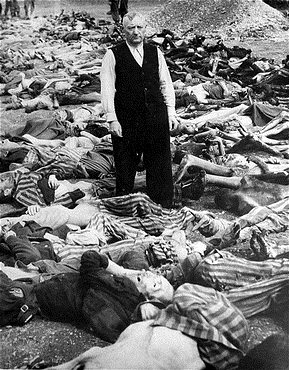
Kaufering was actually a sub-sub-camp system consisting of eleven camps, established to construct and serve an fighter aircraft factory in Landsberg. The camps housed thousands of prisoners, most of them Jews, with some of the camps consisting of little more than partially buried huts as an attempt at camouflage from the air. Six of these camps were liberated by the US 7th Army's 103rd Infantry Division, 411th Regiment, on 27th April 1945. Skeletons of Jews, Poles, Russians, French and non-Nazi Germans littered the sites. In two camps, the soldiers found Jewish men, women and children crammed into huts, 100 people per hut. Officers managed to acquire 1,000 loaves of bread, 1,000 quarts of milk and 750 pounds of fresh meat per day in order to feed the survivors, most of whom were emaciated, weighing just 50 to 60 pounds, the result of years of starvation, forced labour and exposure. In one camp, 300 dead bodies lay on the ground with another 600 'living zombies' wandering around.
On 7th May 2000, a memorial to the 103d Infantry Division (known as 'The Cactus Patch') was comissioned by the late Maurice Lipka of St. Die, a town that was itself liberated by the division. The memorial stands on the site of Kaufering VII, a quarter of a mile south of Highway 26 and 1 mile west of Highway 17 in Landsberg. It rests behind remains of the camp's bunker huts on the site of the former roll-call area.
In 2000, Episode 9 of Band of Brothers, titled Why We Fight, depicted the liberation of one of the Kaufering camps.

This map on Google My Maps reveals the locations of the camps. This information back to a website called www.Kaufering.com which doesn't actually exist anymore (the domain name is currently for sale). However, I am very pleased to say that the owner of the website, Joe Kleon, has got in touch with me and informed me that the Kaufering dot com website has been preserved and can be accessed on the web archive here. I really would recommend visiting this site for further information as there is a lot more on there. Meanwhile, clicking on each of the camp labels in the left-hand column on the Google My Maps site reveals a more precise location which can then be matched up with Google Earth and other information, where it exists, on the wider internet.

Kaufering I/111
According to Dachau KZ blog, Kaufering Lager I was located near Landsberg. It was located near a railway track and was later named Kaufering III. The Google My Maps site identifies its location as being near the current site of the Hans-Pentenrieder-Tennishalle, (the Hans Pentenrieder tennis hall on the north-west edge of Landsberg - See Google Earth image below).
Image: A soldier of the 7th U.S. Army enters the smoking ruins of Kaufering I sub-camp. The original caption reads: "German guards locked their prisoners in the wooden huts and set fire to them. Some burned to death in the buildings, others found strength to crawl out and die in the streets. Most prisoners were naked, but some had remnants of clothing on their charred bodies."
Photographed by Edward C. Newell, United States Holocaust Memorial Museum, courtesy of Stuart McKeever

The area to the north-west of the Han Pentenrieder tennis hall is particularly interesting (see Google Earth image below). A number of buildings are located in the area to the left of the picture. Unfortunately, no 'street view' is available for this area on Google Earth, but these buildings could very well date from the Second World War. The two circular picture icons to the right reveal further information. Clicking on them on the actual Google Earth site brings up an image confirming this area as being part of the 'Landsberg Fraunwald' ('Women's Forest'). The official name of the whole site is 'Commercial and Industrial Park Frauenwald'. A page of the Landsberg am Lech website provides further information, including that it was built on a former military site. That would increase the possibility that these buildings are from the WW2 era.


Moving a short distance to the east, in the direction of the tennis hall, there is rather interesting hut, which looks like a typical military or camp barrack hut.
Interestingly, page 21 of this publicity document for Landsberg confirms that there were two barracks in this area, another document I found on the net said there were four.


Moving even further to the east, to a position immediately north of the tennis hall, a solitary structure stands, again possibly a hut of some kind. Right next to it is the remains of a once clearly metaled road, opening out onto the present road to the north. This former road appears to continue to the south and aligns quite conveniently with the present road running north-south past the tennis hall itself. Could this road once have been a major camp road running through the entire complex?

Judging by the surviving remnants, including what appears to have been buildings and structures, and the ground on which the industrial site now stands, this military complex was indeed extensive.
Saarburg Barracks
Posts on this forum state that the Saarburg Barracks (Saarburg Kaserne) was used as a Displaced Persons (DP) camp accommodating former prisoners from all the Kaufering camps in the area. More information here. This website confirms that the Saarburg Barracks was in use by German soldiers during the war.
Bjorn, in the forum post referred to above, says:
"Immediately after the end of the war, one of the largest Jewish DP camps in Germany was built on May 11, 1945 in the Saarburg barracks. After all, there were not only the 11 well-known concentration camp satellite camps for bunker construction in the Landsberg area, but also several other concentration camp commandos, OT camps, prison camps and, of course, the detention center. At times more than 6,000 Jewish survivors lived here with completely self-sufficient infrastructure. The camp was dissolved on November 1, 1950. Until then, about 23,000 people passed through the camp".
Bjorn also says that the Bundeswehr moved to the Saarburg Barracks in 1957, that it was largely empty from 1991, completely empty from 1993 and that the City of Landsberg bought the entire complex in 1997 for redevelopment.


Kaufering II
The Google My Maps website identifies the site of the Kaufering II camp as being due west of Kaufering I/III, that is due west of the Hans Pentenrieder tennis hall, immediately north-west of a large roundabout.
This WW2 tour guide webpage contains a number of photographs of the site as it is today. It is located just east of the site identified by Google My Maps, alongside, and immediately to the west of the north-south road called Luibach (which joins Buchloer Strasse to the south at a crossroads. A small, concrete building survives surrounded by fenceposts and remnants of the wire fence. Furthermore, just south of this building there appears to be what looks like a small quarry in which the prisoners may have worked.
Another website identifies the site as 'Stoffersberg', which according to Google maps is the area on the other side of the road from this small concrete building. According to that website, Kaufering II was established on the 24th August 1944 and closed on the 25th April 1945. It held around 1,200 prisoners, most of them Jews. On 25th April 1945, 450 prisoners were marched out of the camp, on the orders of SS Hauptscharführer Otto Moll, embarking on a 'death march' to Dachau, the surviving prisoners reaching Dachau on 28th April. The website also states that Kaufering II was a womens camp.
A satellite image accessible via Bing browser marks the position of a memorial to the prisoners of Kaufering II on the western edge of the wooded area to the east of the site.
It seems, judging by a photo taken by writer and photographer Gabriel Fuchs, that the camp area extended into what is now the woodland. The photo shows the site, not in a particularly good condition (see black and white photo below).

Kaufering III
Google My Maps identifies the site of Kaufering III as being on the southern edge of the town of Kaufering, north of Landsberg.

Kaufering IV
Kaufering Lager IV was liberated on 27th April 1945 by the 134th Ordnance Maintenance Battalion of the 12th Armoured Division commanded by Captain John P. Jones. Just previously, the SS had begun marching the inmates of the Kaufering camps to Dachau, but at Kaufering IV they set fire to the barrack huts, killing hundreds of prisoners. Colonel Edward F. Seiller took control and brought 250 civilians from Landsberg to bury the dead prisoners. These 360 prisoners now lie in a cemetery on the site of the camp's roll-call area, about a mile south of the village of Hurlach.
SS officer Johann Baptist Eichelsdoerfer, April 1945, Commandant of Kaufering IV
Executed 29 May 1946 Landsberg

Kaufering V/X
Google My Maps locates Kaufering V on the western shore of the Amersee. The accompanying caption states that the records of the location of this camp are sparse and that the camp was possibly only operating for a short period of time, after which it was relocated and renamed 'Kaufering X'. It may also be identical to Utting sub-camp

Kaufering VI
Google My Maps locates Kaufering VI to the south-west of Turkheim, to the west of a current housing estate.


Kaufering VII
Kaufering VII is located south-west of Landsberg, in a field surrounded by areas of woodland, west of a busy main road. Several of its semi-submerged, concrete, bunker-like, barracks still exist.


Kaufering VIII
Google My Maps locates Kaufering VIII to the south-west of Seestall, near a busy main road.

Kaufering IX
Google My Maps locates Kaufering IX to the east of the road between Hurlach and Obermeitingen. Interestingly, there is a gravel pit nearby.


Kaufering XI
Google My Maps locates Kaufering XI due west of Landsberg and north of Kaufering VII.